Open the USGS Latest Earthquakes Map on your phone or computer and zoom out until the whole planet is visible. At first, the dots may look scattered. After a few seconds, though, long arcs and narrow lines begin to appear around the Pacific, through the Atlantic, across Asia, and along the western edge of the Americas.
/wp:paragraph wp:paragraphThose patterns show where much of Earth’s geological activity is concentrated. Many of the lines follow places where enormous sections of the planet’s rigid outer layer meet, pull apart, collide, or grind past one another.
/wp:paragraph wp:paragraphThe surprising part is how calm the ground feels most of the time. Roads, buildings, coastlines, and mountain ranges seem fixed, yet the plates beneath them may be moving several centimeters every year. That is roughly comparable to the speed at which fingernails grow, according to the U.S. Geological Survey.
/wp:paragraph wp:paragraphA few centimeters does not sound dramatic. Over millions of years, however, that movement can open oceans, close older seas, lift mountain ranges, create volcanoes, and rearrange continents.
/wp:paragraph wp:headingHow tectonic plates move, in simple terms
/wp:heading wp:paragraphTectonic plates are large, rigid pieces of Earth’s lithosphere. The lithosphere includes the crust and the solid uppermost part of the mantle. These plates move over a warmer and more deformable region below called the asthenosphere.
/wp:paragraph wp:paragraphEarth’s internal heat supplies the energy for this system, while gravity and differences in rock density help drive the motion. A cold, dense oceanic plate may sink into the mantle and pull the rest of the plate behind it. Newly formed crust near an elevated mid-ocean ridge may slide slowly downhill under gravity. Movement within the mantle can also influence the direction and speed of the plates.
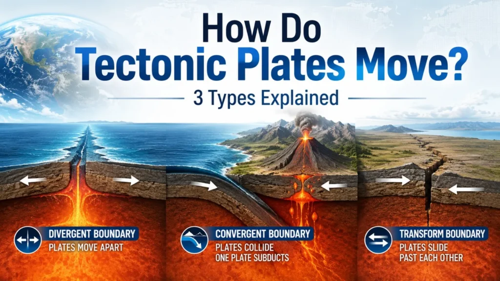
/wp:paragraph wp:paragraphWhere two plates meet, their relative movement creates three main types of boundaries:
/wp:paragraph wp:list {“ordered”:true}- Divergent boundaries, where plates move apart
- Convergent boundaries, where plates move toward each other
- Transform boundaries, where plates slide sideways past one another
NOAA uses the same three-part classification in its guide to plate tectonic boundaries.
/wp:paragraph wp:headingA tectonic plate is not just a piece of crust
/wp:heading wp:paragraphThe words “crust” and “tectonic plate” are often used as though they mean the same thing, but the difference matters.
/wp:paragraph wp:paragraphEarth’s crust is the thin rocky layer at the surface. Beneath it is the mantle, which extends much deeper into the planet. A tectonic plate includes the crust and a rigid section of the uppermost mantle. Together, those layers form the lithosphere.
/wp:paragraph wp:paragraphIf you need a clearer picture of Earth’s outer layer before going further, Sanceen’s guide to facts about Earth’s crust explains its thickness, composition, and relationship with the mantle.
/wp:paragraph wp:paragraphEarth has several major plates, including the Pacific, North American, South American, African, Eurasian, Antarctic, Indian, and Australian plates. Scientists also recognize many smaller plates and microplates.
/wp:paragraph wp:paragraphA plate can carry both continental and oceanic crust. The North American Plate, for example, includes the continent as well as part of the floor of the Atlantic Ocean. Continents are therefore not separate rafts moving on their own. They are carried by larger sections of lithosphere.
/wp:paragraph wp:paragraphThis also explains why a plate boundary does not always follow a coastline. Some boundaries lie beneath oceans, while others cut through continents.
/wp:paragraph wp:headingAre the plates floating on liquid magma?
/wp:heading wp:paragraphThe familiar classroom picture of bright orange material beneath the crust can give the impression that tectonic plates float on a global ocean of molten rock. Most of the mantle is actually solid.
/wp:paragraph wp:paragraphThat solid rock is extremely hot and under enormous pressure. Over a short period, it behaves like a rigid material. Over millions of years, however, it can deform and flow very slowly.
/wp:paragraph wp:paragraphThe asthenosphere is weaker and more deformable than the lithosphere above it, but it is not an open sea of liquid magma. The USGS addresses this directly in its explanation of whether tectonic plates float on magma.
/wp:paragraph wp:paragraphSmall amounts of molten rock do exist in certain regions, especially beneath spreading centers, volcanic systems, and parts of the mantle where melting conditions are met. That is different from saying the whole mantle is liquid.
/wp:paragraph wp:headingWhat makes tectonic plates move?
/wp:heading wp:paragraphA common school explanation says that convection currents in the mantle carry the plates around like objects on a conveyor belt. That is useful as an introduction, but it oversimplifies the process.
/wp:paragraph wp:paragraphPlate motion is better understood as the result of several connected forces.
/wp:paragraph wp:heading {“level”:3}Slab pull
/wp:heading wp:paragraphSlab pull is one of the most important forces in plate tectonics.
/wp:paragraph wp:paragraphOceanic lithosphere forms at mid-ocean ridges. As it moves away from the ridge, it cools, thickens, and becomes denser. When old oceanic lithosphere reaches a subduction zone, it bends and begins sinking into the mantle beneath another plate.
/wp:paragraph wp:paragraphThe descending section is called a slab. Gravity pulls the dense slab downward, and that sinking section can drag the rest of the plate behind it.
/wp:paragraph wp:paragraphA simple comparison is a heavy edge of fabric pulling more material over the side of a table. The real process happens in solid rock under enormous pressure, so the comparison is not perfect, but it helps show how a sinking section can influence the entire plate.
/wp:paragraph wp:paragraphEarthScope’s educational material on forces that drive plate tectonics explains how slab pull, ridge forces, and mantle interactions contribute to plate movement.
/wp:paragraph wp:heading {“level”:3}Ridge push
/wp:heading wp:paragraphNew oceanic lithosphere forms along long underwater mountain systems called mid-ocean ridges.
/wp:paragraph wp:paragraphThe newly formed crust near a ridge is hot and elevated. As it cools and moves away, gravity helps it slide down the gentle slope of the ridge. This is commonly called ridge push, although gravitational sliding is a more intuitive description.
/wp:paragraph wp:paragraphRidge push contributes to plate motion, but it is generally considered weaker than the pull created by large sinking slabs.
/wp:paragraph wp:heading {“level”:3}Mantle movement
/wp:heading wp:paragraphHeat escaping from Earth’s interior causes very slow movement inside the mantle. This movement can apply force to the base and edges of plates.
/wp:paragraph wp:paragraphIt does not behave like one neat global conveyor belt. Mantle flow can help move a plate in one area, resist it in another, or redirect it around a sinking slab.
/wp:paragraph wp:paragraphThe plates and mantle are parts of one interacting system. Plates influence mantle flow, and mantle flow influences the plates.
/wp:paragraph wp:heading {“level”:3}Gravity and density
/wp:heading wp:paragraphGravity is involved throughout the process.
/wp:paragraph wp:paragraphCold oceanic lithosphere sinks because it becomes denser than the material beneath it. Elevated crust near ridges moves toward lower areas. Differences in temperature, thickness, and density help determine which parts of the lithosphere rise, sink, or slide.
/wp:paragraph wp:paragraphThe result is a planet-wide recycling system powered by heat but strongly shaped by gravity.
/wp:paragraph wp:heading1. Divergent boundaries: plates move apart
/wp:heading wp:paragraphA divergent boundary forms where two plates move away from each other.
/wp:paragraph wp:paragraphAs the plates separate, hot mantle material rises beneath the gap. The reduction in pressure allows some of that material to melt. Magma enters cracks, cools, and forms new crust.
/wp:paragraph wp:paragraphThis process is called seafloor spreading.
/wp:paragraph wp:paragraphMost divergent boundaries are located beneath the oceans. The Mid-Atlantic Ridge is a well-known example. It runs through the Atlantic Ocean and marks a spreading boundary between plates on either side.
/wp:paragraph wp:paragraphThe movement is slow enough to be invisible from one year to the next. Over geological time, however, the repeated creation of new seafloor has widened the Atlantic Ocean by thousands of kilometers.
/wp:paragraph wp:paragraphNOAA explains that divergent boundaries commonly form oceanic spreading ridges and are associated with volcanic activity and mostly shallow earthquakes.
/wp:paragraph wp:heading {“level”:3}What happens at a mid-ocean ridge?
/wp:heading wp:paragraphAt a spreading ridge, the sequence is roughly:
/wp:paragraph wp:list {“ordered”:true}- Two plates move away from one another.
- Hot mantle material rises beneath the opening.
- Some of the rising material melts as pressure falls.
- Magma fills cracks or erupts onto the seafloor.
- The magma cools and becomes new oceanic crust.
- Older crust is gradually carried farther from the ridge.
This process does not create an empty gap between the plates. New material continuously fills the opening.
/wp:paragraph wp:heading {“level”:3}Divergence can split continents too
/wp:heading wp:paragraphDivergent movement can begin inside a continent.
/wp:paragraph wp:paragraphWhen continental lithosphere is stretched, it thins and breaks along large faults. Sections of land may sink between the faults, forming a rift valley.
/wp:paragraph wp:paragraphThe East African Rift is one of the clearest modern examples. The region is being stretched and contains faults, volcanoes, deep lakes, and areas of crustal thinning.
/wp:paragraph wp:paragraphA new ocean does not appear quickly. Continental breakup can take tens of millions of years, and not every rift continues far enough to split a continent completely. If spreading persists, however, seawater may eventually enter the widening depression and a new ocean basin can form.
/wp:paragraph wp:heading {“level”:3}Iceland offers a visible example
/wp:heading wp:paragraphMost mid-ocean ridges are hidden beneath deep water. Iceland is unusual because part of the Mid-Atlantic Ridge rises above sea level.
/wp:paragraph wp:paragraphThe island sits in a region where the North American and Eurasian plates are moving apart. Its rift valleys, volcanic systems, and frequent geological activity make plate divergence easier to observe than in most places.
/wp:paragraph wp:paragraphSurface cracks seen at tourist sites are not always a perfect, razor-thin dividing line between two plates. Plate boundaries are often wider and more complicated than the lines shown on school maps.
/wp:paragraph wp:heading2. Convergent boundaries: plates move together
/wp:heading wp:paragraphA convergent boundary forms when two plates move toward one another.
/wp:paragraph wp:paragraphThe result depends on the type of crust carried by each plate. Oceanic lithosphere is usually denser than continental lithosphere, so different combinations produce different landscapes.
/wp:paragraph wp:heading {“level”:3}Oceanic plate meeting a continental plate
/wp:heading wp:paragraphWhen an oceanic plate collides with a continental plate, the denser oceanic lithosphere commonly bends and sinks beneath the continent. This is called subduction.
/wp:paragraph wp:paragraphA deep ocean trench forms near the boundary. As the slab descends, it releases water and other materials into the mantle above it. These substances lower the melting temperature of the surrounding rock, helping magma form.
/wp:paragraph wp:paragraphThe magma may then rise through the continental crust and feed volcanoes.
/wp:paragraph wp:paragraphThe Andes are a major example. The oceanic Nazca Plate is moving beneath the South American Plate, producing a long zone of earthquakes, crustal compression, mountain building, and volcanism.
/wp:paragraph wp:paragraphOne detail is often explained incorrectly: the descending plate does not simply melt like an ice cube. Water released from the slab helps trigger melting in the mantle above it, and that magma can rise toward the surface.
/wp:paragraph wp:heading {“level”:3}Two oceanic plates meeting
/wp:heading wp:paragraphWhen two oceanic plates converge, the older and colder plate is usually denser and sinks beneath the other.
/wp:paragraph wp:paragraphThis process creates a subduction zone and often a very deep ocean trench. Magma generated above the descending slab may form a curved chain of volcanic islands known as an island arc.
/wp:paragraph wp:paragraphJapan, the Aleutian Islands, and the Mariana region are associated with complex oceanic convergence systems.
/wp:paragraph wp:paragraphThese regions can experience shallow, intermediate, and deep earthquakes. They can also generate tsunamis when sudden movement displaces a large amount of seawater.
/wp:paragraph wp:heading {“level”:3}Two continental plates meeting
/wp:heading wp:paragraphContinental crust is relatively buoyant, so neither continent easily sinks deep into the mantle.
/wp:paragraph wp:paragraphWhen two continents collide, the crust is compressed, folded, faulted, and thickened. The result can be an enormous mountain range.
/wp:paragraph wp:paragraphThe Himalayas formed through the collision of the Indian and Eurasian plates. That collision continues to deform the region today.
/wp:paragraph wp:paragraphContinental collisions are strongly associated with earthquakes and mountain building. They do not usually produce the same type of volcanic arc seen above an oceanic subduction zone.
/wp:paragraph wp:heading3. Transform boundaries: plates slide sideways
/wp:heading wp:paragraphA transform boundary forms where two plates move horizontally past one another.
/wp:paragraph wp:paragraphCrust is not created in large amounts, as it is at a divergent boundary, and it is not normally destroyed through subduction. Instead, the plates grind past each other along faults.
/wp:paragraph wp:paragraphThe motion is rarely smooth. Rough sections of rock can lock together while the plates continue trying to move. Stress builds in the surrounding crust until friction is overcome and the fault slips.
/wp:paragraph wp:paragraphThat sudden release of energy produces an earthquake.
/wp:paragraph wp:paragraphThe San Andreas Fault system in California is the best-known example. It marks part of the boundary between the Pacific Plate and the North American Plate.
/wp:paragraph wp:paragraphThe fault is not one clean crack running through the landscape. It is a broad and complicated system containing several connected faults, bends, creeping sections, and locked segments.
/wp:paragraph wp:paragraphThis is why real plate boundaries often look messier than diagrams. The line on a map shows the general location of the boundary, but deformation may be spread across a wide region.
/wp:paragraph wp:paragraphTransform boundaries also occur beneath the oceans, where they connect offset sections of mid-ocean ridges. These areas commonly produce shallow earthquakes.
/wp:paragraph wp:headingHow quickly are the plates moving?
/wp:heading wp:paragraphMost tectonic plates move at rates measured in centimeters per year.
/wp:paragraph wp:paragraphThe exact speed depends on the plate, the location, the direction being measured, and the reference point used. Some plates move slowly, while parts of the Pacific Plate move several centimeters per year and can approach roughly ten centimeters annually in certain comparisons.
/wp:paragraph wp:paragraphScientists describe motion relative to another plate, a hotspot, or a global reference frame. Saying that a plate moves west or north is incomplete unless the reference point is clear.
/wp:paragraph wp:paragraphA useful calculation shows why slow movement still matters. At five centimeters per year, a plate would travel:
/wp:paragraph wp:list- 50 centimeters in 10 years
- 5 meters in 100 years
- 50 kilometers in one million years
- 5,000 kilometers in 100 million years
Plate speeds and directions do change over geological time, but the calculation shows how a tiny annual movement can reshape the planet.
/wp:paragraph wp:headingHow scientists measure plate motion
/wp:heading wp:paragraphPlate tectonics is supported by much more than the visual match between continents.
/wp:paragraph wp:paragraphModern instruments can measure current movement directly, while rocks and ocean-floor patterns preserve evidence of past motion.
/wp:paragraph wp:heading {“level”:3}High-precision GPS
/wp:heading wp:paragraphScientists install GPS stations on stable rock and measure their positions repeatedly.
/wp:paragraph wp:paragraphThese systems are far more precise than the location service in a phone. The USGS notes that satellite-based GPS can measure crustal movement to within a fraction of a millimeter per year.
/wp:paragraph wp:paragraphA station may shift only a few millimeters or centimeters annually, but years of data reveal the direction and speed of movement. Networks of stations also show how the crust bends near locked faults.
/wp:paragraph wp:heading {“level”:3}Satellite radar
/wp:heading wp:paragraphRadar instruments aboard satellites can detect subtle changes in Earth’s surface.
/wp:paragraph wp:paragraphBy comparing radar observations made at different times, researchers can map ground movement caused by earthquakes, volcanoes, landslides, and the slow deformation of faults.
/wp:paragraph wp:paragraphSimilar remote-sensing principles are also used on other planets. Sanceen’s guide to how NASA maps the surface of Mars explains how orbiters, cameras, and elevation data help scientists study terrain that cannot be surveyed directly on foot.
/wp:paragraph wp:heading {“level”:3}Magnetic stripes on the seafloor
/wp:heading wp:paragraphAs molten rock cools at a mid-ocean ridge, magnetic minerals inside it align with Earth’s magnetic field.
/wp:paragraph wp:paragraphEarth’s magnetic field has reversed many times. As new crust forms during periods of normal and reversed polarity, it records alternating magnetic patterns.
/wp:paragraph wp:paragraphScientists discovered matching stripes on opposite sides of mid-ocean ridges. This symmetry became powerful evidence that new seafloor forms at ridges and moves outward.
/wp:paragraph wp:heading {“level”:3}The age of the ocean floor
/wp:heading wp:paragraphThe youngest oceanic crust is generally found near spreading ridges. Older seafloor lies farther away.
/wp:paragraph wp:paragraphOceanic crust is also much younger overall than the oldest continental rocks because it is repeatedly created at ridges and recycled at subduction zones.
/wp:paragraph wp:heading {“level”:3}Earthquake depth
/wp:heading wp:paragraphEarthquakes reveal the shape of plate boundaries.
/wp:paragraph wp:paragraphAt divergent and transform boundaries, earthquakes are usually shallow. In a subduction zone, earthquakes may occur from near the surface to hundreds of kilometers deep.
/wp:paragraph wp:paragraphWhen plotted in cross-section, the earthquake locations form a sloping zone that traces the descending plate.
/wp:paragraph wp:headingA practical way to see plate tectonics yourself
/wp:heading wp:paragraphThe easiest hands-on activity requires only a browser.
/wp:paragraph wp:paragraphOpen the USGS earthquake map and select earthquakes from the past week or month. Zoom out and focus on patterns rather than individual events.
/wp:paragraph wp:paragraphAround the Pacific Ocean, earthquakes form arcs near the western coasts of North and South America, Alaska, Japan, the Philippines, Indonesia, and New Zealand. These regions contain multiple subduction zones and transform boundaries and are commonly grouped under the name “Ring of Fire.”
/wp:paragraph wp:paragraphNext, look down the center of the Atlantic Ocean. Shallow earthquakes follow sections of the Mid-Atlantic Ridge, where plates are moving apart.
/wp:paragraph wp:paragraphThen compare earthquake depths around a subduction zone such as Japan or the western coast of South America. The deeper earthquakes tend to occur farther beneath the overriding plate, tracing the slab as it descends.
/wp:paragraph wp:paragraphThis activity does not turn a reader into a seismologist, but it changes the way a world map looks. The boundaries stop feeling like abstract textbook lines and begin to appear as active geological zones.
/wp:paragraph wp:headingWhy plate movement causes earthquakes
/wp:heading wp:paragraphA plate can keep moving even when part of a fault is locked.
/wp:paragraph wp:paragraphAs movement continues, the surrounding rocks bend and store elastic energy. When the stress becomes greater than the friction holding the fault in place, the rocks slip suddenly.
/wp:paragraph wp:paragraphThe released energy travels through Earth as seismic waves.
/wp:paragraph wp:paragraphAn earthquake does not normally mean an entire plate jumps forward at once. Rupture occurs along a section of a fault, while other sections may remain locked.
/wp:paragraph wp:paragraphPlate tectonics helps scientists identify areas with higher earthquake hazard, but it does not provide a reliable way to predict an exact date, time, location, and magnitude.
/wp:paragraph wp:paragraphClaims that a particular cloud, weather change, animal behavior, or planetary alignment proves an earthquake will happen on a specific day should not replace information from official geological agencies.
/wp:paragraph wp:headingWhy plate movement creates volcanoes
/wp:heading wp:paragraphMany volcanoes form near divergent and convergent boundaries, but the process differs in each setting.
/wp:paragraph wp:paragraphAt a divergent boundary, mantle material rises as the plates separate. The drop in pressure allows some of the material to melt, creating magma that can form new crust.
/wp:paragraph wp:paragraphAt a subduction zone, water and other materials released from the descending plate promote melting in the mantle above it. That magma may rise and feed a volcanic arc.
/wp:paragraph wp:paragraphNot every volcano is located at a plate boundary. Hotspots can create volcanoes inside a plate. Hawaii is a well-known example. As the Pacific Plate moves over a long-lived source of magma, volcanoes form in a chain, with older islands located farther from the currently active area.
/wp:paragraph wp:headingWhy mountains form at plate boundaries
/wp:heading wp:paragraphMountain building occurs in several tectonic settings.
/wp:paragraph wp:paragraphWhen two continents collide, crust is shortened, folded, faulted, and thickened. The Himalayas are the clearest modern example.
/wp:paragraph wp:paragraphAt oceanic-continental convergent boundaries, compression and volcanic activity can create long mountain chains such as the Andes.
/wp:paragraph wp:paragraphMountains can also form when stretched crust breaks into large fault blocks.
/wp:paragraph wp:paragraphUplift is only part of the story. Rivers, glaciers, landslides, weathering, and erosion begin removing rock as soon as mountains rise. The landscape we see reflects the balance between ongoing uplift and continuous erosion.
/wp:paragraph wp:headingFrequently asked questions
/wp:heading wp:heading {“level”:3}What are the three ways tectonic plates move?
/wp:heading wp:paragraphPlates move apart at divergent boundaries, toward one another at convergent boundaries, and sideways past one another at transform boundaries.
/wp:paragraph wp:heading {“level”:3}What is the main force moving tectonic plates?
/wp:heading wp:paragraphNo single force explains every plate, but slab pull is considered especially important. Dense oceanic lithosphere sinks at subduction zones and can pull the rest of the plate behind it. Ridge push, mantle movement, gravity, and resistance along plate edges also contribute.
/wp:paragraph wp:heading {“level”:3}How fast do tectonic plates move?
/wp:heading wp:paragraphMost move a few centimeters per year, although speeds vary. That is roughly comparable to fingernail growth.
/wp:paragraph wp:heading {“level”:3}Can people feel tectonic plates moving?
/wp:heading wp:paragraphPeople do not normally feel the steady yearly movement. They can feel sudden motion when a fault slips during an earthquake.
/wp:paragraph wp:heading {“level”:3}Are tectonic plates floating on magma?
/wp:heading wp:paragraphNo. They move over the asthenosphere, which is mostly solid rock capable of slow deformation. Localized molten rock exists in some regions, but the mantle is not a global liquid ocean.
/wp:paragraph wp:heading {“level”:3}Why are most earthquakes near plate boundaries?
/wp:heading wp:paragraphPlate boundaries are where plates interact and stress becomes concentrated. Most earthquakes occur in these zones, although some happen inside plates along older faults.
/wp:paragraph wp:heading {“level”:3}Can tectonic movement split a continent?
/wp:heading wp:paragraphYes. Continental rifting can stretch and thin the lithosphere. If it continues for millions of years, the continent may separate and a new ocean basin can form.
/wp:paragraph wp:heading {“level”:3}Are the Himalayas still growing?
/wp:heading wp:paragraphThe Indian and Eurasian plates are still converging, so the region continues to deform and experience uplift. Erosion and landslides remove material at the same time, meaning the rate of change differs from one location to another.
/wp:paragraph wp:headingThe ground is moving even when it feels still
/wp:heading wp:paragraphPlate tectonics is easier to understand when Earth is viewed as a slow recycling system.
/wp:paragraph wp:paragraphNew oceanic lithosphere forms at spreading ridges. It cools and becomes denser as it travels away. Some of it eventually reaches a subduction zone and sinks back into the mantle.
/wp:paragraph wp:paragraphContinents move with the plates beneath them. Faults lock and release. Mountain ranges rise while erosion wears them down. Oceans widen in some regions and shrink in others.
/wp:paragraph wp:paragraphNone of this happens fast enough to watch from a window. The evidence appears instead in GPS measurements, earthquake maps, volcanic chains, ocean trenches, magnetic stripes, and folded mountain belts.
/wp:paragraph wp:paragraphThe ground seems permanent because a human lifetime is short compared with geological time. On Earth’s timescale, the surface is still being rebuilt.
/wp:paragraph wp:heading